Unidades organizacionais
In DHIS2 the location of the data, the geographical context, is represented as organisational units. Organisational units can be either a health facility or department/sub-unit providing services or an administrative unit representing a geographical area (e.g. a health district).
Organisation units are located within a hierarchy, also referred to as a tree. The hierarchy will reflect the health administrative structure and its levels. Typical levels in such a hierarchy are the national, province, district and facility levels. In DHIS2 there is a single organisational hierarchy so the way this is defined and mapped to the reality needs careful consideration. Which geographical areas and levels are defined in the main organisational hierarchy will have major impact on the usability and performance of the application. Additionally, there are ways of addressing alternative hierarchies and levels as explained in the section called Organisation unit groups and group sets further down.
Design de hierarquia de unidade organizacional
The process of designing a sensible organisation unit hierarchy has many aspects:
-
Include all reporting health facilities: All health facilities which contribute to the national data collection should be included in the system. Facilities of all kinds of ownership should be incorporated, including private, public, NGO and faith-oriented facilities. Often private facilities constitute half of the total number of facilities in a country and have policies for data reporting imposed on them, which means that incorporating data from such facilities are necessary to get realistic, national aggregate figures.
-
Emphasize the health administrative hierarchy: A country typically has multiple administrative hierarchies which are often not well coordinated nor harmonized. When considering what to emphasize when designing the DHIS2 database one should keep in mind what areas are most interesting and will be most frequently requested for data analysis. DHIS2 is primarily managing health data and performing analysis based on the health administrative structure. This implies that even if adjustments might be made to cater for areas such as finance and local government, the point of departure for the DHIS2 organisation unit hierarchy should be the health administrative areas.
-
Limit the number of organisation unit hierarchy levels: To cater for analysis requirements coming from various organisational bodies such as local government and the treasury, it is tempting to include all of these areas as organisation units in the DHIS2 database. However, due to performance considerations one should try to limit the organisation unit hierarchy levels to the smallest possible number. The hierarchy is used as the basis for aggregation of data to be presented in any of the reporting tools, so when producing aggregate data for the higher levels, the DHIS2 application must search for and add together data registered for all organisation units located further down the hierarchy. Increasing the number of organisation units will hence negatively impact the performance of the application and an excessively large number might become a significant problem in that regard.
In addition, a central part in most of the analysis tools in DHIS2 is based around dynamically selecting the “parent” organisation unit of those which are intended to be included. For instance, one would want to select a province and have the districts belonging to that province included in the report. If the district level is the most interesting level from an analysis point of view and several hierarchy levels exist between this and the province level, this kind of report will be rendered unusable. When building up the hierarchy, one should focus on the levels that will be used frequently in reports and data analysis and leave out levels that are rarely or never used as this will have an impact on both the performance and usability of the application.
-
Avoid one-to-one relationships: Another guiding principle for designing the hierarchy is to avoid connecting levels that have near one-to-one parent-child ratios, meaning that for instance a district (parent) should have on average more than one local council (child) at the level below before it make sense to add a local council level to the hierarchy. Parent-child ratios from 1:4 or more are much more useful for data analysis purposes as one can start to look at e.g. how a district’s data is distributed in the different sub-areas and how these vary. Such drill-down exercises are not very useful when the level below has the same target population and the same serving health facilities as the parent.
Skipping geographical levels when mapping the reality to the DHIS2 organisation unit hierarchy can be difficult and can easily lead to resistance among certain stakeholders, but one should have in mind that there are actually ways of producing reports based on geographical levels that are not part of the organisational hierarchy in DHIS2, as will be explained in the next section.
Grupos de unidades organizacionais e conjuntos de grupos
In DHIS2, organisation units can be grouped in organisation unit groups, and these groups can be further organised into group sets. Together they can mimic an alternative organisational hierarchy which can be used when creating reports and other data output. In addition to representing alternative geographical locations not part of the main hierarchy, these groups are useful for assigning classification schemes to health facilities, e.g. based on the type or ownership of the facilities. Any number of group sets and groups can be defined in the application through the user interface, and all these are defined locally for each DHIS2 database.
An example illustrates this best: Typically one would want to provide analysis based on the ownership of the facilities. In that case one would create a group for each ownership type, for instance “MoH”, “Private” and “NGO”. All facilities in the database must then be classified and assigned to one and only one of these three groups. Next one would create a group set called “Ownership” to which the three groups above are assigned, as illustrated in the figure below.
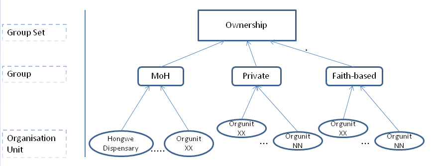
In a similar way one can create a group set for an additional administrative level, e.g. local councils. All local councils must be defined as organisation unit groups and then assigned to a group set called “Local Council”. The final step is then to assign all health facilities to one and only one of the local council groups. This enables the DHIS2 to produce aggregate reports by each local council (adding together data for all assigned health facilities) without having to include the local council level in the main organisational hierarchy. The same approach can be followed for any additional administrative or geographical level that is needed, with one group set per additional level. Before going ahead and designing this in DHIS2, a mapping between the areas of the additional geographical level and the health facilities in each area is needed.
A key property of the group set concept in DHIS2 to understand is exclusivity, which implies that an organisation unit can be member of exactly one of the groups in a group set. A violation of this rule would lead to duplication of data when aggregating health facility data by the different groups, as a facility assigned to two groups in the same group set would be counted twice.
With this structure in place, DHIS2 can provide aggregated data for each of the organisation unit ownership types through the “Organisation unit group set report” in “Reporting” module or through the Excel pivot table third-party tool. For instance one can view and compare utilisation rates aggregated by the different types of ownership (e.g. MoH, Private, NGO). In addition, DHIS2 can provide statistics of the distribution of facilities in “Organisation unit distribution report” in “Reporting” module. For instance one can view how many facilities exist under any given organisation unit in the hierarchy for each of the various ownership types. In the GIS module, given that health facility coordinates have been registered in the system, one can view the locations of the different types of health facilities (with different symbols for each type), and also combine this information with another map layer showing indicators e.g. by district.